Land surveying is mandatory if the plot needs to be sold, donated or inherited. Any other legal operations with the site that are carried out to change the configuration or size of the land also require the preparation of a boundary plan.
Why do this?
Land transactions
When making civil transactions involving the transfer of ownership of land, the boundaries of the site must be clearly defined. The fact is that any legal transactions are carried out with land, which has clear boundaries. The only way to determine these boundaries today is land surveying.
Defining boundaries
Sometimes, during the use of a land plot, the owner needs to determine or restore boundaries. If the land was purchased or received ownership a long time ago or the documents have not been preserved, a boundary plan must be drawn up. Sometimes establishing boundaries is required if mistakes were made in the past during land surveying.
Allocation of land from collective ownership
If the land is collectively owned, then in order to allocate a land plot to an individual member it is necessary to establish the actual boundaries of the plot. The obligation on this issue falls on the shoulders of the future owner.
Redistribution
The process of dividing one plot into several owners or, conversely, if several plots are transferred to the possession of one owner, requires the preparation of a new boundary plan. In this case, new land plots are formed, the boundaries of which should be established. In order to obtain a cadastral passport in this case, it is necessary to carry out land surveying and obtain a land survey plan.
Registration of ownership
When registering ownership of a land plot, it is necessary to establish clear boundaries of this land plot. Any registration of property rights and ownership of the plot is carried out only if there is a boundary plan.
Increase in area
According to the Land Code of the Russian Federation, each land owner can add to it a part of the land that is not anyone's property. Such a procedure can be carried out in any legal way with subsequent addition of data to Rosreestr. To establish the exact boundaries of the new site, you will need to draw up a boundary plan.
Dispute Resolution
Resolution of disputes between neighbors is carried out exclusively by contacting the body for registration and accounting of land plots (Rosreestr). But Rosreestr usually does not deal with these problems on its own; it sends the owners to the court, which initiates the procedure for land surveying to make a decision.
Construction of a permanent structure
In order to build a house or other building on a plot, the owner must comply with the requirements of laws and regulations, for example, adhere to certain parameters (spacings, setbacks, etc.). The determination of any parameters and dimensions of the structure is compared with the exact boundaries of the site, and therefore is carried out in accordance with the boundary plan.
Lunar path with paints
Are you still thinking about what beautiful drawing to draw? Let's look at how to draw a very beautiful picture with paints. For work, prepare gouache paints, water, brushes and a sheet of paper.
Now all you have to do is stock up on inspiration and you will certainly succeed. In fact, a drawing technique will be considered, which a junior school student can easily master, because all the stages are described in detail.
Involve children in creativity, and you will certainly have fun and useful leisure time together.
What the law says
Due to changes in the new Federal Law of the Russian Federation No. 447, which regulates cadastral activities, it is now impossible to sell or donate land without a boundary plan. Since until 2008 this was not a mandatory condition, many owners do not have such a document.
Now, before selling a plot or transferring it by inheritance, the owner must spend money on drawing up a boundary plan and wait from 10 days to 2 months until the plan is ready.
Division by horizon
In order to highlight the horizon, it will be enough to dip a thin brush into white paint and draw a horizontal line across the entire drawing.
Fade the sky a little with a pink tint, make blurry strokes. To do this, you can dip the brush a little in water and you will succeed. At this stage, the part of the drawing that is above the horizon is ready.
Required documents
To order land surveying, you need to collect the following documents:
- Passport of the land owner or a power of attorney certified by a notary, if the owner’s representative is handling the paperwork.
- Documents for land that confirm who the owner is. This may be a gift agreement, a certificate of inheritance, or a purchase and sale agreement.
- Certificate of ownership of land or an extract from the Unified State Register of Real Estate.
- Cadastral passport or cadastral extract.
- If there are buildings on the site, then they must have a passport .
Deciding on a method
You can draw with an ordinary pencil, colored pencils, paints, felt-tip pens. Various non-standard drawing techniques, for example, with charcoal, are now being actively introduced.
Each paint and pencil requires a special approach; you need to know how to use them. If we talk about the first steps in this art, then just choose what you like. If these are paints, it would be better to use watercolor or gouache.
Samples of land surveying documents
The boundary plan contains all the information about the land plot, including the owner’s data and the designated boundaries of the plot, and its basis is an extract from the Unified State Register of Real Estate. The document also contains information that the engineer considered necessary to enter after inspecting the plot. Information that is taken into account in the boundary plan:
- A graphic representation of the land plot, including turning points through which land surveying occurs;
- Information about the characteristics of the land plot and information that is different from other plots;
- If boundaries and plans have undergone changes, then it is indicated what and when;
- Conclusion of a cadastral engineer with references to the law (if required);
- The act of approval of boundaries is signed by neighbors on the site, if any.
The boundary plan includes text and graphic parts. The text part includes all information about the land plot, including the act on the approval of boundaries. The cadastral engineer enters the following data into it:
- Initial information about the site;
- What calculations and measurements were carried out;
- What changes were made to the land surveying in the past;
- Information about neighboring plots;
- Conclusion of a cadastral engineer.
- An act of approval of the boundaries of the site, signed by the neighbors.
In the graphic part of the plan there is a drawing depicting all the roads passing between the site. The following information is posted here:
- diagram of the object and neighboring areas while maintaining scaling;
- drawing of the site highlighting its components (if any);
- outlines of turning (nodal) points through which the boundary lines of the site pass.
The plan is issued on disk and on paper in 2 copies, one to the cadastral engineer, the second to the owner of the site. You can also obtain a cadastral plan in electronic form, but you should notify the cadastral engineer about this in advance.
Features of compilation: Preparation requirements
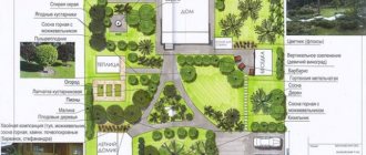
The topographic plan of the site must meet the requirements. The diagram is produced on a scale that is selected depending on the purpose. Maps with a small scale do not allow you to highlight individual objects. For construction, in the vast majority of cases, plans with a scale of 1:500 or 1:1000 are used. The document may include not only a map of the area, but also additional images.
When using conventional symbols, the diagram can display the following objects and unusual features of the site:
- Relief. Depicted as horizontal lines. Those relief elements that cannot be represented by contours are marked using special symbols.
- Terrain objects that can be used as landmarks. They are depicted by off-scale signs and are precisely tied to coordinates.
- A road network depicted in detail using conventional symbols for different types of roads.
- Hydrography. Large lakes, swamps, rivers and other bodies of water are marked on topographic plans, indicating names, depths, etc.
- Soil and vegetation cover. Depicted using separate off-scale symbols and color.
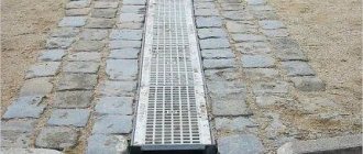
- Engineering Communication. Topographic plans identify both above-ground communications and those located underground.
Inscriptions are made in certain cartographic fonts, taking into account the location rules. A stamp is provided in the lower right corner of the map, which contains all the necessary information regarding the scale, date of production and location of the depicted area.
Topographic survey is carried out using geodetic equipment, tacheometers, GLONASS/GPS equipment. Thanks to this, it is possible to obtain certain results of measuring the site plane, elevation characteristics, coordinates and other characteristics. Geodetic equipment is characterized by an excellent level of reliability, which is why it is not afraid of dust and moisture.
has its own geodetic equipment, which undergoes regular testing, which in turn allows measurements to be taken with excellent accuracy. Expert software is used to draw up topographic plans.
How to carry out land surveying
If the owner of the site decides to carry out land surveying, then he must find a cadastral engineer and contact him. You can choose a specialist based on the advice of relatives or by searching on the Internet. But before you enter into an agreement with him, you should check whether he can be trusted.
The cadastral engineer must:
- be a member of an SRO (self-regulatory organization);
- have a personal seal for “paperwork”;
- have an electronic signature certificate for “electronic files”.
You can check the information on the official website of the SRO or in the state register of cadastral engineers on the Rosreestr website. To do this, you only need to enter the last name, first name and patronymic of the cadastral engineer. If next to the specialist there is an entry “included in the register,” then you can contact him to draw up a boundary plan. By the way, in the specialist’s card you can find additional data: how many years he has been working, whether there were any errors or failures in his activities.
Be careful! If a cadastral engineer is not included in the SRO register, then he cannot perform cadastral work (including land surveying). Documents prepared by such a specialist will not have legal force.
The cost of drawing up a boundary plan for different cadastral engineers can be different; it varies from 2 to 10 thousand rubles. The boundary plan is drawn up within 10 days, but there are delays of up to 2 months. The efficiency of drawing up a document depends on how quickly and correctly all the documents are collected by the owner of the site.
Landscape with colors
Let's look at how to draw a beautiful drawing easily, even if you don't know how to draw. If you follow the step-by-step instructions, then you will certainly succeed, and you will be satisfied not only with the process, but also with the result.
To draw a pink sunset you will need to prepare paper, brushes, water and paints:
- pink;
- blue, it is better to choose the color ultra-marine if you have it in your palette;
- rich yellow;
- black.
When everything is prepared, you can start creating beauty.
How is land surveying carried out?
After collecting all the documents and concluding a contract for the work, the owner of the site must pay for the services of a specialist and discuss with him the date of the site visit. On the appointed day, a surveyor or cadastral engineer arrives at the site with special GPS equipment and measures the boundaries of the site, determining their actual coordinates. After receiving the boundary plan, a copy of it is sent to Rosreestr.
When establishing the boundaries of a plot, the data obtained is agreed upon with the owners of neighboring plots if:
- the area under study has common boundaries with them;
- the neighboring plot is not visible on the cadastral map;
- the owner of the neighboring plot has a document of ownership of this plot.
In the event that land surveying is needed to combine several plots or to divide one plot, there is no need to compare the boundaries and coordinate this with neighbors.
Details
Now draw the bottom of the drawing below the horizon. Here you need to draw the water and the shore.
Note!
How to draw a squirrel: TOP-120 photos of the best drawing methods and techniques. Step-by-step master class for beginners with examples of the best drawings
How to draw anime - useful tips and simple diagrams for beginners. Instructions with the basic steps of drawing anime (160 photos)
3D drawings: TOP-150 photos of the best methods and techniques. Step-by-step DIY drawing master class for beginners
Since the overall picture conveys an evening sunset, it means that the water and the shore will be painted with pink paint. Leave the bottom right corner for the shore, and on the rest of the part use light pink paint to paint the water, play with colors to convey the water with the waves.
The difference between land surveying and cadastral work, geodesy and privatization
Land surveying is often confused with other procedures in the field of land management. Let's look at each of them.
Cadastral work is a type of work on the preparation and preparation of any documents on real estate. This includes drawing up a technical and boundary plan.
Geodesy is responsible for measuring, designing and processing data in the form of drawings; it is necessary to draw up a plan for the placement of objects on the site. A surveyor can determine and establish the boundaries of a site on a par with a cadastral engineer, as well as perform calculations of excavation work on a site, determine the vertical and horizontal lines for a construction site, and outline construction sites and placement of communications.
Land privatization is the transfer of state property into personal property. The owner of the plot receives documents for the right to own the land and the opportunity to dispose of it at his own discretion: sell, donate, inherit.
Manufactured types of topoplans
- Geobase. Compiled on a scale of 1:500. All utilities and the road network must be marked on the plan. This topographic plan must be consistent with the operating organizations.
- Horizontal shooting plan. Typically, this type of diagram does not contain information regarding terrain and elevation. Necessary for cutting land, recording a given area, etc.
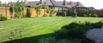
- Tree plan. This plan is executed on a huge scale of 1:100 or 1:200 and is characterized by detail. The diagram can display relief, vegetation cover, water bodies, etc. The tree plan is used in landscape design and when carrying out landscaping work.
FAQ
Is it true that a law has been passed according to which land surveying of a summer cottage can be carried out free of charge?
According to No. 221-FZ chapter 4.1. money has been allocated to carry out comprehensive cadastral work. That is, land surveying and drawing up boundary plans are carried out not for one site, but for an entire cadastral quarter. A plan for carrying out complex work is drawn up by local authorities. You can find out in which settlements and in which areas complex work will take place from the media or on the portals of local governments. Owners of plots that belong to a certain cadastral block must only provide access to the territory of the plot, and money to pay for land surveying will be allocated from the budget.
What to do if a neighbor does not give his consent to determine the boundaries of the property?
You should double-check the documents and try to resolve disagreements peacefully. If you can’t reach an agreement, then write a complaint to the prosecutor’s office and then to the court. Then the boundaries will be determined in court and a boundary plan drawn up.
Is it possible to carry out land surveying for free under the dacha amnesty?
The dacha amnesty allows you to quickly and free of charge register the land and buildings on it as your property. But the dacha amnesty does not include the land surveying procedure, which must be ordered separately.
Is land surveying a mandatory procedure for land owners?
This legislation does not require owners to carry out mandatory land surveying. But if you intend to sell the house or pass it on by inheritance, then by law this cannot be done without a boundary plan. Also, timely land surveying will allow you to avoid conflicts with neighbors over illegally seized lands.
Draw with a pencil
Initially, many people think that it is simply unrealistic to draw beautiful drawings yourself, but after studying some information or watching master classes, this opinion may change for many. Let's look at how to draw a beautiful drawing with a pencil.
First you need to decide what exactly you want to draw. It could be a human face, animals or fairy-tale characters. Don't limit your imagination.
Conclusion
- You cannot carry out land surveying and determine the boundaries of the site yourself; for this you need to have a license for geodetic and cartographic activities.
- Land surveying is not a mandatory procedure for land owners. But if transactions involving the transfer of land ownership are planned, the boundaries of the site must be clearly defined, which means that a boundary plan will be required.
- When choosing a cadastral engineer to draw up a boundary plan, check whether he is a member of an SRO. If a specialist is not a member of a self-regulatory organization, then the documents that he draws up will be considered invalid.
Drawing the sky
Let's move on:
Apply a small amount of blue on top of the leaf. Apply ultramarine paint. If it happens that the blue mixes with the previously applied layers of paint, carefully wipe off the previous layers with a cloth.
Mix ultramarine with pink. Apply the resulting shade below the blue. This move will give your painting an evening look.
Next you need to achieve a darker color, to do this, play with ultramarine and pink, add more colors. At each stage of mixing, check whether the resulting shade suits you on an additional sheet of paper, a draft. Using the resulting shade, draw a line parallel to the horizon; these will be stripes of clouds. They should not be continuous, but abrupt.
Note!
Easy gouache drawings - TOP-160 photos and step-by-step instructions for drawing with gouache. Best Reviews of Easy Drawings for Beginners
Drawing ideas: TOP-200 photos of the best ideas for do-it-yourself drawings + reviews of techniques with simple drawing schemes
Pencil drawings are easy and beautiful - a master class on pencil drawing for beginners. Simple diagrams with a description of the work + photos of the best drawing ideas
To prevent the clouds near the sun from being too contrasting, take a dry, clean brush and rub the edges a little.
At this stage, the drawing of the sky stops.