Construction of a house begins with drawing up a master plan for the land plot. The start of laying utility lines must be based on a package of permits, which includes a general plan. To draw it up correctly, take into account the properties of the terrain, the location of all buildings, fire safety requirements and coordinate this document with the BTI, administration and architectural department.
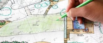
Example of a general plan of a land plot
What is the essence of the master plan
Russian Government Decree No. 87 dated February 16, 2008 states that this is a document containing land planning, site development, as well as any work that will be carried out on the site during construction. A document is prepared by superimposing a drawing of the future object on a topographic (photographic) base at a scale of 1:2000, 1:500, 1:200. The master plan can be drawn up for both an individual building and a microdistrict. The approved set of drawings of the plan being developed must have:
1. General information about working sketches.
2. Cadastral plan with plot dimensions.
3. Relief diagram.
4. Sectional drawing with soil layers.
General plan of the site in Moscow
5. Drawings of utilities - water supply, gas mains, electrical wiring diagram for the house, sewer system, etc.
6. Documentation for landscaping a personal plot.
7. Remote fragments – neighboring objects, roadways and other structures located nearby.
The registration requirements are the same throughout the Russian Federation. They operate both in Moscow and anywhere else in the country.
Tips for house location
If the site has various uneven surfaces, with slopes in one direction or another, then it is recommended to build the building on a hill. If this is not possible, and the house is being built in a low-lying area, then all possible measures must be taken to protect the structure from flooding.
Ideally, the house should be located parallel to the horizontal, on small slopes: buildings without basements can be located on slopes of up to 7%, with basements - up to 12%.
If the steepness of the slope is 1:2, then it will be necessary to erect retaining walls to ensure high-quality stability of the subgrade.
According to accepted standards, the building must be located at a distance of approximately 5-6 meters from the red line (the border that separates the site from the line), retreating from neighboring sites by approximately 3 meters.
Sample master plan for a garden plot
In areas where utility lines pass, the construction of any structures, as well as the planting of tall trees, is prohibited.
Purpose of the document
A master plan is necessary for two reasons:
- Its preparation is a mandatory legal requirement, and without completed documentation, construction cannot begin. Compliance with established standards guarantees the safe operation of the building. Therefore, the master plan of a private house contains fire safety and sanitary requirements. Thus, in accordance with established standards, the gap between the walls of a residential building and the road should be 5 m, and the width of the canvas should be 3.5 m. Such requirements guarantee the free movement of equipment or fire trucks.
- Sketches and descriptions of work are a guide for construction. A properly designed project distributes buildings and auxiliary facilities throughout the yard. This is a complex that includes a residential building, a garage, a garden or vegetable garden, a swimming pool and/or bathhouse, etc. Therefore, when ordering even a standard project, you can propose your own changes.
Explanation of boundary approval
Advice: It is better to formulate a master plan for the land plot in parallel with the house design in order to provide for all the features of the area being built up.
Documentation for the planning of a future cottage (or other residential building) is coordinated with the architectural authority of the corresponding locality and its existing plan for the entire territory. To resolve any controversial issues, you must contact the administration.
Where to apply, terms and cost
When the entire package of documents has been collected, you need to contact the Committee on Architecture and Urban Planning. There you fill out an application according to the sample, and also submit all documents.
In each case, the period for drawing up a plan takes a different amount of time. When contacting a private organization, the work will be completed much faster.
If the application was submitted to a government agency, then the entire process will be free for the owner. A private organization will require payment for this, however, as mentioned earlier, they will do the general plan much faster and, possibly, of better quality.
Consistent design of the master plan
The beginning of the compilation consists of collecting documents:
- House layout approved by the locality architecture service.
- Site drawing.
- The results of geological surveys, topographic and geodetic surveys - a general plan drawn up on a scale of 1:500.
- Requirements for connecting housing to centralized communications.
Minimum permissible distances between objects
Formation of the document is carried out step by step:
1. Deciding on specific buildings. At this stage, a list of objects is compiled, with their dimensions determined and the distance to the fence (or neighbors’ houses). Next, for each specified building, it is necessary to register, taking into account what sanitary standards its construction will be carried out.
2. Drawing of the appropriate scale: 1:500 or 1:20,000. The display size is selected based on the underlying basis used: situational, general or reference plan. The designed communications and relief characteristics are brought into compliance.
3. Making a decision on the placement of buildings on the territory.
Important: It is necessary to take into account slopes and dips in the terrain, normalized distances between objects.
Formation of a dendrological plan of the site and a drawing indicating other elements.
5. Making final adjustments as per the requirements of the home owner. After final approval, all the details are recorded on paper.
Example
For example, for a plot of 1,100 m2 in size you will have to pay 1,650,000 million rubles, if you count the average cost. Of course, the cost of a general site plan is not small, but you get a guarantee of high-quality development of the plan in an extremely short time. After receiving the plan in hand, you can contact the housing inspection yourself or, for an additional fee, order this service from the same architectural bureau in which the drawings were developed for you. Remember that without registering a plan with a government agency, your development will be considered illegal.
Documents for the formation of a master plan
The following are used as the basis for its preparation:
- cadastral plan of land for future buildings. On such a diagram, the boundaries of the site are defined and there is a graphical representation of it;
Graphic display of the area
- a description of each of the possible buildings erected;
- a diagram showing all objects in the adjacent territory, the roadway;
- situational plan. This is a site location map. The name of the locality, region and country must be indicated here. It looks like a photo from space;
- reference plan. This is a kind of diagram indicating all construction projects in the yard, green spaces;
- drawing of utilities: sewerage, electrical connections, gas pipeline, water main, indicating the points of entry into the building;
- diagram of preparatory operations on the site with highlighting elevations.
Sample situation plan
Why know the wind rose, take into account the relief and groundwater level
If insolation is somehow taken into account, then the wind rose is conveniently forgotten, while this factor is no less important when planning a site.
From my practical female point of view, the compass rose is important. The prevailing wind direction must be taken into account when locating windows, especially when there are many and they are large. When placing the front door. When planting plants. Those plants that cannot withstand constant wind, especially in winter, should be placed on the side protected by buildings. And also smoke - baths, barbecues. It would be nice to place them so that the smoke does not go straight into your neighbor’s windows.
You can find out which winds prevail either by observing your site, but this will take more than one day, or through various online resources. Both global and regional wind maps are freely available, with the ability to construct a more accurate graph. You cannot specify a specific SNT or cottage community on them, but a schedule for a regional city or large regional center will give an approximate picture. Owners of low-lying areas can afford not to worry too much about the wind, but those on high ground should think about it in advance. To, if necessary, plan a blocking hedge, a closed gazebo instead of an open one, and turn the house with a blank wall towards the coldest stream.
The relief , especially pronounced, radically influences the layout and arrangement of the territory - it is advisable to locate buildings on a hill, otherwise you will have to be tricky with the removal of moisture that rolls down from above, from the foundations, and is absorbed into the ground. And this is not only a storm drain, including a drainage system and trays along the blind area and paths, but also full drainage. With a strong slope, terracing and the installation of retaining walls may be required, and they take up to 20% of the total area.
Groundwater level affects both the choice of construction technologies and the choice of planting material. In particularly advanced cases, when most of the year the water stands at a spade level, you will need not only foundation drainage for the dacha itself, but also radial drainage to drain the land on the site. The drained water needs to go somewhere; it’s good when there are drainage ditches, but in new areas they are very rare. If space allows, it is worth planning a pond in the lowest place of the yard, which can be interestingly designed and turned from a storage “tank” into an element of landscape design.
It is quite possible to do without soil analysis at the planning stage.
What's the point of doing a soil analysis? The soil in the Moscow region is practically the same, only the mechanical composition is different - this can be determined simply by looking at it without analysis. It is enough to add peat, for example, for loosening. And when planting, fertilizers are always added and also when caring for the garden.
Landscape design is carried out not only in the Moscow region, but throughout the country, but there are also plenty of sites with soil maps, including for each region, on the Internet.
Nuances during formation
Please note that:
- You cannot plant tall trees and build houses where communications are located;
- if the soil is prone to waterlogging, the area should be provided with a drainage system;
- on uneven terrain, it is better to build buildings at some elevation;
- When building a house on a slope with a slope angle of ≥ 1:2, it is recommended to strengthen the soil with supports, and also to plant trees with a deep root system nearby.
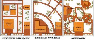
Where to start arranging the site: planning, zoning, diagrams
An attractive and functional site for a comfortable country life is no less important than a cozy house with convenient layouts and life support systems. In order not to have to improve the territory according to the residual principle, trying to harmoniously fit at least everything necessary, you need to think about landscape design not after the construction of housing, but much earlier. Proper planning of a summer cottage is an opportunity to “squeeze” the maximum out of an allotment of any shape, topography and dimensions, locate the house in the most suitable place and provide optimal conditions for plants. With an integrated approach, when the site is first thoughtfully planned, and only then built up and planted, there is a much greater chance of getting an excellent result the first time, rather than getting bogged down in endless rework.
Content
Sample master plan
The figure shows a standard example of developing a personal plot on a scale of 1:500. Structures and plants are indicated here, details of the terrain, sidewalks and garden paths, entrances for vehicles, etc. are reflected. The more details and details there are, the easier it is to carry out further work.
Although the cost of the document is high, it is mandatory to have it. Otherwise, the entire process will subsequently be declared illegal by the urban planning department.