Vertical site planning is a set of engineering measures aimed at artificially transforming, changing and improving the existing terrain to achieve urban planning goals by adding soil or cutting it off. It is carried out if the existing topography of the construction area does not meet the requirements of horizontal planning.
The key goal of vertical planning is the formation of planned surfaces that meet the requirements of engineering improvement and territory development. With its help, conditions are created for the construction of various capital construction projects, the placement of utilities, the laying of streets, etc.
What problems are solved using vertical planning?
Proper planting of a house on an uneven plot of land will solve several serious problems, namely:
- efficient operation of storm and drainage sewers;
- correct formation of pits and trenches for foundation structures;
- the exact location of the walls of buildings and structures relative to the snow cover located near objects on the ground.
In fact, these problems are significant because the long-term operation of a house built on an uneven suburban site depends on them. These problems are being solved today with the help of the same vertical layout. And for this, several construction and survey operations are carried out:
- First of all, a geodetic survey of the territory . You can do without it, but to do this you will have to determine the plane difference .
Topographical survey of an uneven area Source refreshmsk.ru
- Determine the level of groundwater , as well as the level of freezing .
- Then the area is backfilled , leveling it horizontally . In general, horizontal site planning is the most effective way to solve almost all the problems mentioned above.
- The next stage is choosing the type of foundation structure . Everything will depend on the depth at which the groundwater . Shallow structures can be laid for low-rise lightweight construction . If a large, heavy house is being built, you will have to calculate and design a drainage system . the height of the base at this stage .
- A storm drain is formed and the blind areas are poured . As for the storm sewer, you need to decide what type it will be: closed or open . Of course, a drainage scheme outside the suburban area.
In principle, all of the above activities do not pose any particular difficulties for a professional team. Let's just look at each stage separately so that you understand what we are talking about.
Design of foundations and a house on an uneven site Source atlant-gk.pro
Geodetic topographic survey
This stage requires knowledge, experience and skills in working with special equipment. The measures taken make it possible to accurately indicate the angle of the soil slope in one direction or another. This is an important point that gives a start to the competent implementation of other construction operations.
In addition, at this stage, other necessary indicators are determined:
- type of soil on the site and its technological characteristics;
- the level of groundwater, which negatively affects the technical condition of the foundation;
- soil freezing level;
- degree of frost heaving of the soil.
After conducting a topographic survey and analyzing the data obtained, it becomes clear how uneven the acquired land is. And it could be:
- very smooth and horizontal ;
- have a plane difference within 0.4 m;
- or in the range from 0.4 to 1 m;
- or have a steep slope exceeding 1 m.
Using a level, the value of the difference in territory is determined Source sain.com
Adding soil
Experienced builders assure that backfilling should be carried out regardless of what slope the site has. In many cases, even flat areas are raised to lower the groundwater level. This is expensive at first glance. But compared to other protective measures, bringing in and leveling the land will be inexpensive.
What other advantages does bedding have:
- the bearing capacity of the land located under the foundation increases
- the level of soil freezing decreases , and this means a decrease in the forces acting under the influence of frost heaving;
- it becomes possible to more easily organize the drainage of melt and rainwater from the construction site;
- the thickness of the soil above the groundwater level increases
- during the operation of a suburban area, the level of the ground around the house , that is, the latter ends up in a hole , and the bedding does not allow this to happen;
- soil removed from pits and trenches can be used for backfilling , which reduces the cost of its transportation and disposal .
Backfilling an uneven area with soil Source pesok-klmn.ru
See also: Catalog of the most popular sites in the Moscow region for the construction of suburban real estate.
Layout on a flat area
As an example of the vertical layout of a flat type plot, this is a flat area, but located in a lowland, where precipitation and water from melted snow constantly flow. The conditions under which it is possible to build a house on such a site are bedding, plus the use of a shallow foundation. Sometimes pile structures are used.
The thickness of the bedding in this case is 20-50 cm. However, soil, that is, soil with plant and other organic inclusions, cannot be used here. Take clean, dense soil. The perimeter of the poured area is covered with a sand-gravel mixture, which is compacted well.
Building a house on a slope
There are two technologies for constructing a foundation on a slope.
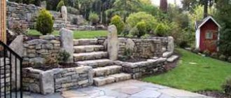
- A foundation structure is formed , which is aligned along the upper end . That is, a trench , and in its lower part the filling is carried out in formwork placed horizontally . The photo below shows a strip foundation assembled from stones and built on a slope. It should be noted that a combined foundation option can be used on a slope. On the high part of the slope, a strip-type structure is poured, and piles are mounted on the low part.
Strip foundation on a slope Source readmehouse.ru
- The second option is to use bedding . If the difference in the plane of the territory does not exceed 1 m, then the process itself is carried out as leveling the site. Sometimes the high side of the territory is simply cut off with a bulldozer and transferred to the low part. If the difference exceeds 1 m, then it is impossible to do without bringing in soil from outside.
If the first of the two options was chosen, but the work contractor is faced with the task of leveling the site, then usually the scheme of work is as follows: first, a foundation is built based on its height and horizontality, and then the area around the foundation structure is leveled. But this will all depend on what design project of the suburban area was chosen. Because landscape designers often leave the slope and make it the basis of the design. For example, as in the photo below.
House built on a slope Source rwwanganui.co.nz
And one more point that concerns the pillow poured under the foundation. You can't make it fat. This parameter should not exceed 60 cm. In this case, it is necessary to lay the pillow material in layers, leveling each one and compacting it. The reason is that even well-compacted sand or crushed stone cannot boast of the density and load-bearing capacity that natural soil located below the soil layer has. That is, over a certain period of time the pillow will shrink. And the thicker it is, the greater the percentage of shrinkage, and these are cracks on the walls of the constructed house.
If the slope difference exceeds 1 m, then the best option for a house is a basement room formed by the slope, and all other rooms are located in the main part of the building, erected on the base of the foundation. Again, so that you understand what we are talking about, the picture is below.
House on a slope with a ground floor Source bel-dom-stroy.ru
It should be noted that the soil on the slope is subject to quite serious loads from the building being erected. There is a danger of soil convergence along the sliding plane. And this can happen if the mass of the building exceeds the load-bearing capacity of the soil deck. Sometimes the bearing capacity is reduced due to rain and melt water moving down the slope. This problem is solved with blind areas and a drainage system.
But it is the type of soil that allows you to accurately determine its bearing capacity. That is why it is so important to conduct geological research at the first stage.
And one moment. In the upland part of the slope, forces act that push the foundation down. Therefore, it is very important to accurately calculate the depth of the structure. That is, it is better not to use the shallow-depth option here.
Construction processes
The vertical layout of the construction site is used in the further construction of residential, industrial buildings and complexes. The following work is required:
- destruction of plant soil;
- creation of a leveling embankment;
- moving the leveling embankment with leveling and distribution of soil;
- The final stage is final planning.
Before performing the work described above, a diagram is created.
It comes in two and three cards. The two-map scheme of vertical planning and engineering preparation of the territory includes soil filling and leveling. The soil is also compacted. And the three-card scheme also includes moistening the soil and allowing it to settle for a certain amount of time. The technological map of vertical planning work must contain the following elements:
- graphical diagram;
- accounting for the volume and costs of labor resources;
- level of balance of earth masses;
- detailed description of production methods;
- accounting of equipment and vehicles used during work;
- regulations on labor protection and environmental protection.
Atmospheric precipitation removal
As mentioned above, for this you will have to build a blind area and lay a drainage system.
As for the first, for this purpose, a backfill of durable soil or a mixture of sand and crushed stone 10 cm high is made around the entire perimeter of the house. That is, it is necessary to begin the construction of a winding on a site that will be higher than the plane of the main soil.
The width of the blind area is 80 cm, the angle of inclination away from the foundation is 5°. Usually it is filled with concrete mortar, but you can use asphalt or piece slab products (stone or concrete), which are laid without gaps. The main requirement for the blind area is one hundred percent water impermeability. If the soil in a suburban area is heaving, then the blind area is filled not with a single strip, but in sections with length dimensions ranging from 1.5-2.5 m.
Blind areas of a house built on an uneven plot Source www.remontnik.ru
As for the storm sewer system, first of all it is necessary to understand that before construction began, melt and rain water flowed down the elephant without encountering any obstacles on its way. The erected house on the mountain side is a huge insurmountable obstacle. Therefore, it is in this place that water will accumulate. It must be diverted skillfully, for which they use trays installed along the foundation located on the upland part of the slope, with a slight slope away from the house, but along it.
Now about deep drainage. It is constructed only if the soil on the site is sandy, but below it there is dense clay soil that does not allow water to pass through. During the rainy season, water passes through the sand, but does not penetrate the clay. An aquifer is formed, which is called perch. It is very dangerous for the foundation. Therefore, at the level of the high water, drainage pipes are laid, with the help of which water is drained.
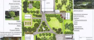
Zoning of the site
Chaotically “scattered” across the building plan, interspersed with flower beds, paths and lawns - the worst option, comparable to its absence. Whatever the area and shape of the site, the territory is always divided into functional parts, otherwise it is zoned. Zoning greatly simplifies placement, since all objects and elements are accumulated in “their” zones, diluted with garden decor or plantings. As a standard, areas are divided into several zones.
Main
The main building of a suburban area is a residential building, and the area in which it is located becomes the main one. On small plots or medium-sized plots, up to ten acres, the layout provides for the location of the house as close to the border as possible, maintaining a minimum setback from the road and the neighbor's fence. If you build it in the center or move it deeper, it will be much more difficult to fit in a recreation area, outbuildings, and find a place for a garden, vegetable garden, and flower beds. The house occupies from 10 to 15% of the territory; when a large area is needed, but the second floor or attic is categorically not liked, this share is increased to 20-25%. To prevent the shadow of the building from covering the area for most of the day, it should be correctly placed in the northwestern or northeastern part.
TimyCh Member of FORUMHOUSE
It is very important which side the house is placed on. I bought a plot with a house already built, without options. And it is positioned very incorrectly (southwest), as a result - I have only half a day of sun on my site. I was forced (there was nowhere else) to place the bathhouse towards the east, and in the end I only had about one and a half hundred square meters left with good lighting, and the rest of the area was in partial shade and full shade.
To obtain maximum natural light, when designing the layout, living rooms and common areas (kitchen, living room) are made with windows facing south and southeast. The northern side is reserved for technical rooms with small windows or no windows at all.
In the main area, a permanent garage or shed is usually located in order to shorten the access route as much as possible and not go from the parking lot to the house through the entire yard.
Front door
A front entrance area (front garden) is arranged in front of the house, which is allocated for landscaping elements. It is she who sets the tone, so it is designed as spectacularly as possible: different types of flower beds, shrubs, compositions, beautiful paving, some arrange fountains or waterfalls with decorative ponds in the front garden. There is only one goal - to capture the imagination from the very first steps, especially if the architecture or decoration of the house cannot cope with such a task. The front area in compact areas is formed due to the necessary setback from the road; when the area is large, the front garden is also expanded. But they still don’t build any additional functional facilities in this part of the site.
Private
It is also a recreation area, removed away from prying eyes and occupying up to 15% of the entire territory. But this share can be increased if the family likes to relax passively and actively, but tinkering with the garden is not so much. In small areas of an elongated rectangular shape, a recreation area is made behind the house, practically fenced off from the entrance. When the plot of land is square or there is more space, and the house has a corner location, other buildings or hedges act as barriers. These can be not only perennial shrubs and conifers, but also climbing plants on a trellis, with an arched passage or pergola gate. The recreation area may contain a bathhouse, a swimming pool, stationary or mobile, an artificial pond, decorative or decorative swimming pool, an open or closed gazebo, a patio or a fire area. The most convenient, especially if there is little space, are multifunctional structures - a gazebo with a stove complex or a patio with the same, a bathhouse with a terrace, a pergola with garden furniture or a swing. Capital gazebos with massive stoves and glazing can be used all year round, gathering by the fire on weekends or holidays.
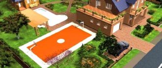
If there are small children in the family, they need a children's playground, with a sandbox and a house. For teenagers, a sports ground with a basketball hoop, a trampoline or horizontal bars is more relevant, and where a court with a sports turf will fit. In the private area, as in the front garden, there is a place for landscaping, if not horizontal, then vertical - flowerpots with hanging plants, vines on figured supports. The arrangement of private areas depends solely on the preferences of the owners and their capabilities, the minimum is a summer gazebo (patio, terrace) with furniture in which you can gather for tea or something stronger and a barbecue, at least metal.
Garden Garden
On areas of sufficient area (12-20 acres) where there is no need to plant greenery in flower beds or in tubs above the entrance, a garden and park area is arranged behind the resting place. There is also a vegetable garden in it, if someone from the family gravitates toward growing vegetables for the table. The beds, now mostly stationary and high, are built in the sunniest place in the southern part of the yard, since most crops are sun-loving and grow in the shade, but do not bear fruit. It is also advisable to plant fruit trees in the south, but they can be “pushed” to the border by retreating the required meter. In regions with high solar activity, it is allowed to plant fruit and ornamental trees directly in front of the windows to provide shading over time. Where there is already little sun, this is not practiced. Most of the yard is allocated for a vegetable garden, but everything is individual, when no one is particularly eager for the glory of a vegetable grower, it is better to immediately increase the number of various buildings, lawn coverings and decorative objects.
In the garden part of the yard there is a compost pit or box, and outbuildings for storing equipment, consumables, tools and small equipment. This is more practical than dragging hoses, wheelbarrows, trimmers or cultivators from the garage across the entire site. But it’s more convenient to attach the woodshed to a bathhouse or house, again, so as not to add extra meters. If you approach its construction with imagination, it will become not only a reliable storage facility, but also one of the decorations of the yard.
The number of zones is individual and directly depends on the area and characteristics of the site, preferences and capabilities of the owners. On 6 acres there are two zones - the main one with the house and front garden, and the private one behind the house. When the area amounts to tens of acres, the scope of imagination is limited only by the budget and the territory is divided into many parts with their own functionality.
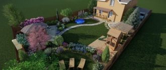
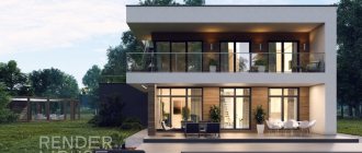
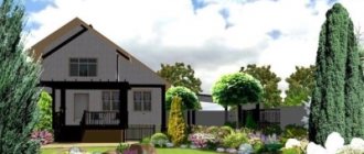
Here is a clear example of successful planning with zoning and implementation, from a member of our portal - Irina, with the nickname Malinovaya 18.
Visualization.
What happened.
What it is?
Vertical layout (VP) of a land plot - preparation for artificial transformation of the natural terrain, preparatory stage of construction.
Work begins with geodetic measures to determine the coordinates and heights of surface points and spatial objects. Sometimes it is enough just to determine the actual height difference.
Based on the research results, it is concluded how much the surface is deviated from the ideal horizontal.
At the next stage, it is assessed how high the groundwater lies and how much the soil swells from low temperatures.
Before vertical planning, preparatory work is completed, unnecessary soil and vegetation layer, trees and shrubs are removed.
Planning objectives are to optimally adapt the land for construction and living:
- level the terrain;
- highlight zones with slopes;
- determine places for arranging slopes, stairs, terraces;
- reduce the groundwater level, create effective drainage;
- provide optimal conditions for plants;
- combine the zones of the site with a single architectural and stylistic idea;
- outline the lines for laying underground communications.
Artificial relief is created during excavation work: softening slopes, cutting or adding soil, constructing local embankments.
How to make a diagram?
Land plots for construction, regardless of the topography, require accurate calculations and diagrams.
On a geodetic basis:
- indicate the location of objects;
- The design surface is marked with red lines.
Lines formed by the intersection of the base with other planes are projected onto the plane by horizontals. The pitch is 100-500 mm, depending on the scale, conditions and complexity of the arrangement.
You cannot cut off the horizontal lines; they must go through the entire plan, and the section remains unchanged. An acceptable case of contour breakage is the connection of design surfaces with slopes, walls, and fences.
If it is planned to add soil, the red lines are moved back, indicating a decrease. The area where land acquisition is planned will be elevated in the diagram.
The slope, which is constant throughout its entire length, is reflected by the equal distance of the horizontal lines from each other. The angle between the lines, indicating the marks of low terrain, indicates the ridge; in the opposite case - to the notch.
Surface water will be drained at right angles to the red lines. Horizontal lines with a closed concentric contour surrounding one another are denoted by:
- hill - the center is occupied by higher lines;
- depression - closer to the middle the lines decrease.
This information is enough to read and implement the vertical planning scheme.
Design project
Any site should be not only convenient, but also beautiful. Therefore, territory planning is usually carried out with the simultaneous preparation of a design project. In suburban construction, when decorating the local area, two styles are most often used:
- Landscape. In another way, this direction is also called picturesque. In this case, plants are placed without following strict rules, paths can be curving, and landscape elements are arranged naturally.
- Geometric. This style is usually chosen for areas located on level ground. Its characteristic features are precision of lines and shapes, strict geometry.
Land survey plan
Planning the territory of a land plot (private) is an officially optional procedure. It is necessary to carry out land surveying. This is an official document and only licensed companies or individuals can draw it up. Without a boundary plan, it will not be possible to register ownership of the site. The procedure for its preparation is determined by law. Previously, existing information about the site is collected. This could be, for example, old sales contracts, drawings, etc. Then the work is carried out directly on site. At the same time, the site is inspected, its area and boundaries are determined. Next, preliminary surveying is carried out. After all approvals, the boundaries of the site are finally assigned.
A completed boundary plan is a mandatory part of the package of documents submitted to the Cadastral Chamber. In addition, for registration, a technical passport is required, which contains information about the buildings located on the territory, a document confirming ownership, etc. After being entered into the register, the site is considered legally registered. This makes it possible to carry out purchase and sale transactions in relation to it, draw up gift agreements, etc.
Means, tools, equipment
To measure differences in memory and marking you will need:
- level;
- building level;
- roulette.
Geodetic work is carried out only by professionals with special equipment. Site planning (filling, cutting, moving, loosening the soil) is carried out mechanically or manually.
In the first case, heavy special equipment is rented:
- bulldozer or grader;
- tractor with cultivator or bucket.
When working independently, a walk-behind tractor with a cultivator and a cutter for cutting soil is used.
For manual work you need:
- shovels;
- choppers;
- rake;
- scrap;
- pegs;
- sledgehammer or hammer.
To remove trees and bushes from the area, an ax, saw, and hacksaw will be useful. To transport soil you will need a wheelbarrow.
Is it possible to get by?
If during the construction of a house VP was not carried out, or was carried out unprofessionally, the consequences can be disastrous:
- The house tilts with gradual destruction. If the site is not leveled, the load on the foundation will be distributed unevenly, which will lead to cracks, structural instability, and collapse.
- Inability to maintain a garden. Flooding that is difficult to predict is destructive to soil and crops.
- Problems of engineering communications. The eroded soil will cause damage to electrical networks, sewerage systems, and wastewater treatment plants.
- Impossibility of building a ground floor and basement: there is a high risk of flooding and collapse in the event of eroded soil movement.
- Rotting of wooden buildings under the influence of increased levels of precipitation.
Due to the washing out of the soil and the instability of the site, it becomes impossible to build light buildings: gazebos, bathhouses and sheds.
What kind of memory is absolutely necessary?
Uneven landscapes limit the developer: not all projects are suitable for implementation; the construction of a pile foundation may be required. In addition, uneven areas are susceptible to soil erosion by rain and melted snow.
Based on the relief factor and elevation differences within the boundaries of the development area, the land plots are classified as:
- smooth;
- with a slight slope: ≤0.5 m;
- with a significant slope: 0.5-1 m;
- with a steep slope: ≥1m.
Experienced builders believe that every site needs bedding: even flat areas should be raised to lower the groundwater level.
Benefits of Execution
Previously, it was impossible to obtain a construction permit without a VP. Now a document is not required - private developers simply notify the local administration in writing about the fact of the upcoming construction.
However, VP is necessary. Moreover, it is precisely during the period of pre-project preparation, in order to properly plant the house vertically:
- prepare the construction site surface;
- calculate the height of the base.
Carrying out planning work after the construction of a house is irrational and economically unprofitable.
Planning of the territory of a linear facility
In this case, the project is drawn up in approximately the same way. Its main part includes drawings with the boundaries of the administrative structures on the territory of which the linear facility will be laid, with the designation of transport networks, power lines, etc. It is accompanied by materials justifying the construction, in the form of text and graphic documents.